Design, Construction and sustenance of geographic Information System(GIS)
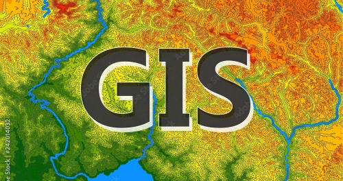
>GIS for Federal Ministry of Environment
Extended ArcGIS for Desktop Application using ArcObjects SDK.
Our experienced team has successfully completed numerous projects, establishing a strong legacy in the industry. We confidently excel in the following areas;


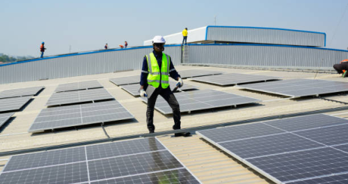
OneGeoSpatial Nigeria Limited have the expertise to provide quality general electrical design and installation, civil engineering design and construction, maintenance of the electrical and civil engineering Infrastructure etc. Our qualified and highly skilled electrical and civil engineers can assist you with any type of common repair. installation or replacement of electrical services including; regular lighting maintenance such as changing the light gloves or fitting new lights in an office
At OneGeoSpatial, we are dedicated to pioneering cutting-edge technology that drives progress and transforms industries. Our mission is to empower businesses and individuals with innovative solutions that enhance efficiency, connectivity, and sustainability. Through relentless pursuit of excellence, we strive to be the catalyst for a brighter, smarter, and more interconnected future.
We envision a world where technology seamlessly integrates into every facet of our lives, enabling boundless opportunities for creativity, collaboration, and growth. OneGeoSpatial aspires to be at the forefront of this revolution, shaping industries, fostering innovation, and inspiring a global community of change-makers. Together, we aim to redefine what's possible in the digital age.
With any company's success, responsibility arises towards its environs, the society in which it operates. Responsibility, which the company itself perceives and sometimes loudly demanded by its fellow citizens. Responsibility which ultimately becomes a key factor for a truly sustainable business prosperity of the company. Companies often invest in significant funds into their corporate social responsibility (CSR) projects, but are rarely able to measure their impact. Without a clear strategy and carefully designed processes, the spending on "charity projects" often becomes money send the drain. In fact, the company can end up with accusations of corruption in the media instead of public praise.

Conversion and re-projection to original spatial reference of as-built engineering drawings from any picture format (.TIFF, .GeoTIFF, .JPG, .JPEG2000, etc.) to any CAD format. We equally handle all OGR vectors and GDAL rasters. Copies of Infrastructure master plan is strategic for planning its maintenance. Hard copies as-built drawing do not afford this flexibility where master information is to be transmitted in any form. Also, where information transmission requires accuracy, immediacy, and existence of the data in transmittable formats becomes very vital. More also, where stringent measures are not observed for hard copies save-storage, disasters can destroy it from existence.

Documents get damaged over time, when improperly archived. This might be due to the storage or archival condition and safety plan considered. If the document is so vital that at every point in time copies are needed, digitization is a sure way out as a means of salvaging the mutilating documents. Digitization is all about scanning of drawings to convert it into digital format and e-books. Likely drawings and documents to be digitized are usually in sizes A0, A1, A2, A3, legal, letter, A4, etc. In this method, copies of bound documents are unbound so that scanning can be easily conducted. These same documents shall be bound when digitization is completed. The followings are the minimum quality standards for engineering drawings; Readability, Alignment, Maximum Sharpness, Appropriate placement of inserts, Proper sequence of storage of documents on hard disk/DVDs, indexing with hyperlink should be as indicated by the clients, scanning in original color, minimum resolution of 400dpi, and capability with all electronic device.
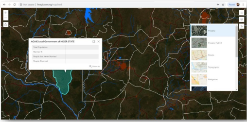
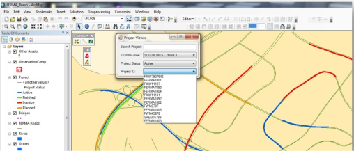
This area entrances us to multidisciplinary solution, geographic Information System for capturing, storing, querying, analyzing, managing, and displaying geospatial data. OneGeoSpatial have painstaking know-how in the area of assembling hardware, software, people, and infrastructure together.
In the Electronic Documents and Records Management System (EDRMS) we leverage on the capacity of Microsoft SharePoint Server for delivering a collaborative architecture that gallantly simplifies an enterprise-wide solution on. SharePoint, a web application framework and a platform developed by Microsoft, integrates intranet, content management, and document management, with other capabilities.

7+
Years of Services
5+
Global partners
96%
Customer Retention
20+
Projects